June 10 to June 30
 After a brief intermission, I was driven up to Mojave again by my friend Angel and her father, and started hiking again from Tehachapi Pass. According to the guidebooks, this is the geologic southern end of the Sierra Nevadas, but it certainly didn’t feel like it. It felt like Southern California for the first 150 miles or so until Kennedy Meadows. Although the terrain varied quite a bit, there were a couple dry stretches.
The resumption of my trek was in some ways similar to how I began from the Mexican border – three weeks off had caused me to lose some of my edge, my mental focus and physical form. But I picked it up again much quicker this time, in time for the higher elevations of the High Sierras, which started after Kennedy Meadows. The biggest difference from starting out was that while there were many people around as I hiked in Southern California, especially the first few days around the Kickoff, I did not see a single living soul for the first three and a half days. I saw a truck in the distance and a number of airplanes overhead, but that was it.
 This was probably the longest stretch of time in my life I’ve ever been alone in the sense of not seeing another human being. I remember quite well going down the steep little trail to Little Jimmy Spring and being shocked — after more than three days of seeing no one, there were a half-dozen thru-hikers relaxing and filling up their water bottles. I commented on the fact that they were the first people I’d seen in three and a half days on the trail, and they too were surprised. But then we realized what had happened – the section I was hiking was not particularly popular for
  non-thru-hikers, (dry, not too scenic) so I really should only have seen thru-hikers. And while I was now near the end of the group of thru-hikers (somewhere between 150 and 200 were ahead of me on the trail at that point), there should have been hikers behind me. But there had been a forest fire further south near Agua Dulce that had shut down a section of the trail for a couple days (the six had been the last through before the trail closed), thus creating a ‘hole’ in the flow of thru-hikers, which I had by chance started hiking in when I rejoined the trail at Tehachapi Pass.
Well, it was pleasant seeing people again, but I quickly got over the people thing. Once I got to Kennedy Meadows, and from there through Yosemite, there were a huge number of people on the trail. The bulk of the thru-hikers were in the High Sierras, and it was the beginning of tourist season. I remember a random stream several days out from Kennedy Meadows – I got there maybe 12:30 and there were already four thru-hikers parked for lunch (two pair). I stopped and joined them, and four more thru-hikers (a pair and two singletons) showed up and joined us for lunch.
That being said, the Sierras were amazing. I have to go back, though I think next time I’ll try for a little earlier, face more snow and fewer people. Not only is the scenery awe-inspiring, I had the misfortune of breaking my camera five days past Kennedy Meadows, so I only have a handful of rolls of film for some of the most beautiful scenery along the entire trail.
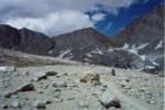
 The highest point on the trail (above sea level) is Forrester Pass (13,180′), and the snow melted sufficiently that although it was a fair amount of climb, there were no really dangerous exposed snow banks to cross on the north side climbing, and the south side, while time consuming, was not dangerous either. The picture of me atop Forrester Pass was the first one in which I was dubbed the ‘terrorist in blue.’ The trend of my face being shadowed in most of the pictures is fairly constant throughout all 40 rolls of film as I almost never took my hat off for pictures and hate squinting into the sun.
Although the snow was not a problem on any of the passes for me when I crossed them in mid to late June (while it was a heavier than normal snow year in the PNW, in the southern Sierras it was a light year), the most dangerous part was fording snowmelt flooded streams and rivers. Without a doubt the most dangerous experience I had along the trail was crossing such a river. This was after my camera died, so I have no pictures, but the experience is etched permanently in my mind.
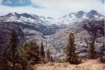
 The longest stretch of trail along the PCT without any roads, and without any resupply, begins at Kennedy Meadows, and, for most thru-hikers, ends at the famous (among hikers at least) Vermillion Valley Resort (VVR). 180 miles total, much of it hiking above 10,000′ with a dozen named passes to cross. It’s rough and tiring, and absolutely amazing. I made it through this stretch in eight days, though I would have loved to stay longer and explore more (some other time). The last night before arriving at VVR I had a little extra time to kill, so I decided to stay at hot springs near Muir Trail Ranch. Only when I arrived I realized I had to cross a torrential river to get to the other side and the hot springs. Asking a couple camping by the river, I found out there was a log about a quarter mile up that people generally had no problem crossing. Naturally, I looked at the river, which was well above my waist, and decided to ford it right there. I would be soaked of course, but I was going to be getting wet on the other side anyway in the Hot Springs, so what was the big deal?
 While this sounds like an invitation to disaster already, that evening actually worked out even better than planned. I got thoroughly soaked crossing the river, but did not get swept away (though it was touch and go). Actually I would have been perfectly dry from about my belly button up if I hadn’t slipped just as I was getting out. But because I’m paranoid and have gotten all my gear soaked hiking in the NW before, everything is at least double-bagged in ziplocs and or heavy duty garbage bags, and it all came out just fine (even my down sleeping bag). And on the opposite side, the hot springs were well worth it. Not only that, some generous souls camping there for the weekend shared their campfire and gave me chicken burritos and a Guinness!
I got up early the next morning – about 5:30 or so I think – having decided that I’d take the log back in the morning because I didn’t want to get wet early in the morning. So I wandered up the river and found the log. I looked at it with a bit of trepidation, not only because I had gone nearly 900 miles on the same pair of trail running shoes at that point and thus had very little traction left, but because the very middle of the log was under water – about two or three feet of the log, at its deepest maybe half a foot under water.
 Fool that I was, I tried to cross. When I got to the middle, my feet were swept right off the log and I jumped into the river. I know that sounds funny, but what was going on in my mind as I lost balance was that if I hit my head on the log when I fell, I was dead for sure, so when I was losing balance I jumped into the river. While I hadn’t really been quite awake until that point, upon entering the river I my eyes were wide open. It was 5:30 in the morning. It was fresh snowmelt. It was cold. But adrenalin is a marvelous thing and as I was swept downstream, I kept my head above water and gradually swam to the opposite shore (hampered by my hiking poles, but actually buoyed by my backpack). And eventually I ended up getting out of the river more or less where I forded it the night before – maybe two hundred yards downstream.
I was freezing cold and it was just before six o’clock in the morning (and still fairly dark out), so I quickly took stock of the situation. Net loss: my glasses (actual a minor blessing in disguise, as they were starting to annoy me) and two aspirin. I could stop and try to dry off and warm up, or just keep on going. I decided to strip down to my polypro and keep on hiking, counting on the sun to dry me off, which it did within an hour. I then had a mostly pleasant hike the rest of the way to VVR. Talking to other hikers at VVR I found out that in fact, I had attempted to cross the wrong log. There was a much safer one, several feet around and several feet above the water, another hundred yards upstream. Well, now I know about it for next time.
 At VVR I also found out about the original owner of my new shorts – a fellow thru-hiker who went by the trail name of Tangent. For the first part of my trip I had worn rather distinctive Okinawan half-pants, which although some may claim are a bit loud and tacky, I don’t care about fashion and was extremely pleased with them – they were lightweight and I liked the length (I like long shorts generally for hiking). The only problem was that they were simply thin cotton, and thus not particularly durable. After 800 miles or so I had worn through their backside, leaving gaping holes in embarassing places. This was not something I had adequately thought through, clearly. I had no replacement shorts coming, and my subsequent resupply locations: Kennedy Meadows, and then VVR, were not likely to have stores that sold shorts.
So without much hope, and nothing else I could do, I duct-taped the back of my shorts together so as to be at least somewhat presentable as I got into Kennedy Meadows. Indeed the general store in Kennedy Meadows did not sell shorts, although they had some shirts for sale. But then fate intervened in the form of the hiker box. A hiker box is a box where hikers leave extra supplies (nonperishables, fuel, gear, etc.) for other hikers who may need them. And wonder of wonders it had a pair of shorts. Not only that, they were in mint condition. There was only one drawback to the shorts. They were mplayer.com shorts – they had the funny little symbol in purple on the front and the name, and across the backside they had in big yellow letters mplayer.com’s slogan — Wanna Play? Alas, these shorts gave out just as I got to Ashland, and were a replaced with a much plainer pair.
I spent the least amount of time in the Sierra Nevadas of any part of my hike, something necessitated by my schedule, but I figure I have a lot of time left in my life, and spending more time in the Sierras is definitely in the plans. And I certainly don’t look back on the longer time I spent in Northern California with any regret.
The PCT in Central California
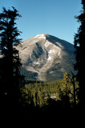
The section of the trail from Tehachapi Pass begins with a nice climb into some pretty terrain, but then drops back down into a long dry (and fairly hot) stretch that isn’t particularly interesting. But starting with the approach to Kennedy Meadows it gets much nicer – the area that had a forest fire a few years ago was full of wildflowers when I went through. From Kennedy Meadows the trail climbs into the real Sierra Nevadas and for a couple hundred miles rarely drops below 8000′. After the PCT joins the JMT and then crosses Forrester Pass the scenery becomes even more incredible. If only my camera hadn’t died…
