July 1 to July 25
 Independence Day has never been high on my list of favorite holidays. While I love summers in general, the fireworks and food that generally occur, and consider myself fairly patriotic, the 4th of July just doesn’t have the same weight in my mind as other holidays. Most of my 4th of July’s just meld together in my memory and I can’t recall where I was or what I was doing.
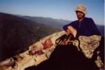
That’s certainly not the case this year. On the 4th of July I was hiking on the PCT a few miles west of Lake Tahoe. There were a lot of people out on the trails for an absolutely beautiful day and when having lunch I met up with a couple who were dayhiking on the trail who generously gave me phenomenal deli sandwich, Clif bar and a bag of cherries! The winds along the ridges south of Donner Pass as I descended in the late afternoon/ evening were so strong that at times I found myself being pushed sideways. I made it to Donner Pass around 8 p.m. or so and people were already gathering along the highways and trails. They had blankets out and were eating and drinking in good cheer. It was still light enough to go on, but I just had to stop for the fireworks over Donner Lake. I laid out my pad and sleeping bag and right from the PCT, between the two highways that go through Donner Pass, watched the most amazing display of fireworks I can remember seeing. This was totally unplanned, and I wonder how many places along the PCT you can see fireworks on the 4th of JUly – a handful at most. But it is this sort of happenstance, the unexpected good fortune that always seemed to find me, that made the PCT trip so special.
 There was a cost, of course, to watching the fireworks. I absolutely had to make sure I arrived in Sierra City in time to make my post office pickup before it closed for the weekend. The 4th of July was a Thursday, meaning I had Friday and possibly a little bit of Saturday to hike the 41 miles. While the terrain was mostly ideal for hiking – just a few 1000′ climbs, mostly a gentle descent, 41 miles is long. But the following day, after staying up later than normal to watch the fireworks, I got up at 5 a.m. (earlier than I had gotten up since trying to avoid the heat in SoCal) and hiked the entire 41 miles to Sierra City, arriving at 10 p.m. That was my longest single day on the trail (followed by my two 39 mile days in SoCal).
 Sierra City turned out to be one of my favorite little resupply towns, with free camping and showers at the RV place, a decent market and nice and friendly people. It is also a haven for mountain bikers, some of whom ride illegally on the PCT. Even in retrospect, I still am irritated. A couple of my encounters with mountain bikers on the trail probably are up there as the most frustrating/annoying things to occur the entire 7 seven weeks on the trail. The ones I met coming down the PCT toward Sierra City knew that the PCT banned mountain bikes and still assumed that they had the right of way when they were racing towards me downhill at breakneck speed. I enjoy mountain biking, but mountain bikes don’t belong on the PCT. The purpose of the PCT is to allow people to experience wilderness – something that just isn’t possible when you are almost run over by mountain bikers rushing down hill at you. The afternoon I left Sierra City I ran into 6 of them in a span of less than 15 minutes. I
  refused to give way to the bikes (they can go around me), and let them know I don’t appreciate their activities. I hope that other hikers do the same – enforcement of the laws by rangers is too intermittent (though I always mention the $500 fine for being caught), so it is vital that social sanctions are imposed when the situation arises. I also appreciated the fine work by a couple other thru-hikers who pulled branches across the trail. Nothing that a hiker couldn’t step over as a matter of course, but large and frequent enough to give the mountain bikers a less pleasant ride.
I should probably mention the other frustrating thing about the trail in Northern California: the notorious Section O. Without a doubt the most frustrating, overgrown stretch of trail I’ve hiked in a long time. Overgrown to the point where you cannot see the trail at times. Not just overgrown with soft undergrowth and poison oak (which fortunately I seem to be fairly resistant to), but with shrubs that have branches so thick that walking through them left scratches and bruises. Fortunately, the really unkempt sections didn’t seem to stretch across more than a day or two of hiking, so it was quickly over with.
 Despite the negatives, Northern California was full of amazing experiences. While I saw dozens of amazing sunsets, without a doubt the most impressive
 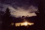 was the one I saw a few days shy of the Oregon-California. After a light afternoon thundershower, the rain I had had in weeks, I set up camp a bit early along a small protected area facing East atop a ridge near Bingham Lake. The sunset seemed to last forever, was truly incredible. Literally half the sky was lit up with golds that gradually turned crimson as if the sky was on fire.
I continued to see great sunsets over the next week or two in southern Oregon, but for rather unfortunate reasons. You can read about that here.
The PCT in Northern California
 Leaving the High Sierras, the PCT descends to pass a few miles west of Lake Tahoe. It then jaunts northwest through lower mountains and hills, hiking along ridges and crests for stretches and then dropping down to cross rivers and visit resupply towns. This means that the biggest climbs tend to be done when your pack is the heaviest. If only they’d build the towns high up in the moutains… a common thru-hiker fantasy in this section. That being said, the hiking really is quite good and you can put in a lot of miles in quickly if you’re motivated.
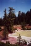 To me the great thing about Northern California was finally, after months of hiking, reaching the Cascades. They felt like home. There are truly awe-inspiring sections of the Sierra Nevadas, but the Cascades are different. The Cascades are stratovolcanos, single peaks visible for hundreds of miles, dominating the vistas, the landscape. As you hike around them for weeks, you get to see different views, different angles and backgrounds. The southernmost peak is Lassen, which you can see in the distance for hundreds of miles, until you are on its slopes and visit its amazing boiling lakes. For weeks you see Shasta in the distance, you loop around it for hundreds of trail miles in fact, as the trail heads west to visit Burney Falls, Castle Crags and the Marble Mountains before turning north again and entering Oregon.
